Explore the Map of Nigeria Showing Major Rivers and Their Importance
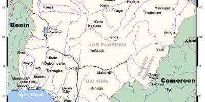
Nigeria is a country rich in natural resources and diverse ecosystems, and its rivers play a critical role in its geography and economy. A map of Nigeria showing major rivers provides valuable insight into the country's waterways, which are essential for transportation, agriculture, and supporting local communities. The major rivers such as the Niger and Benue Rivers are not only the lifeblood of the nation but also serve as vital sources of freshwater, supporting both people and wildlife.
The Niger River, the longest river in Nigeria, stretches over 4,180 kilometers and flows through several states before emptying into the Atlantic Ocean. The river has been a significant waterway for trade and transportation for centuries, facilitating commerce and cultural exchange among different ethnic groups. The Benue River, which is a major tributary of the Niger, contributes significantly to the Niger Delta's diverse ecosystem and provides irrigation for agriculture in the surrounding areas. Understanding the routes and tributaries represented on the map helps highlight the interconnectedness of these waterways and their impact on regional development.
Historically, these rivers have been central to the livelihoods of many communities. They have been used for fishing, farming, and as a source of drinking water. The map illustrates not only the rivers but also their surrounding landscapes, showcasing the lush vegetation and fertile lands that depend on these water sources. Additionally, the rivers have been crucial in shaping the cultural practices and traditions of various Nigerian communities, with many festivals and rituals closely associated with water.
Geographically, the map of Nigeria's major rivers reveals the country's diverse topography, from the mountainous regions in the northeast to the coastal plains in the south. This variation in terrain influences the flow of rivers and their tributaries, which can lead to seasonal flooding in certain areas. Understanding these geographical features helps in disaster preparedness and resource management, particularly in regions prone to flooding.
Practically, the map serves several purposes for different stakeholders. For policymakers, it aids in planning infrastructure projects and managing resources effectively. For environmentalists, it provides crucial data for studying biodiversity and assessing the health of aquatic ecosystems. For educators and students, this map is a valuable tool for learning about Nigerian geography and the importance of its rivers in both historical and contemporary contexts. The map is not just a representation of waterways; it is a reflection of the cultural and ecological significance of these natural resources.
In conclusion, the map of Nigeria showing major rivers is an essential tool that highlights the significance of these waterways in the country's geography and history. Exploring this map allows one to appreciate the vital role that rivers play in shaping the socio-economic landscape of Nigeria, making it a valuable resource for anyone interested in the nation's geography and culture.
By understanding Nigeria's major rivers through this map, you can gain a deeper appreciation for the country's geography and its natural resources. Explore further to discover the rich cultural heritage tied to these waterways.
-
The Niger River is the longest river in Nigeria, spanning over 4,180 kilometers, and is the third longest river in Africa.
-
The Benue River is the second longest river in Nigeria, with a length of approximately 1,400 kilometers, and it merges with the Niger River at Lokoja.
-
The Niger River basin is home to diverse wildlife, including several endangered species such as the African manatee and the Nile crocodile.
-
The Niger Delta, formed by the Niger River, is one of the largest and most biodiverse wetland regions in the world, hosting a variety of flora and fauna.
-
The river system in Nigeria supports more than 50 million people, providing water for drinking, irrigation, and fishing.
-
Historically, the Niger River served as a trade route that facilitated the exchange of goods, cultures, and ideas among ancient civilizations in the region.
-
The waters of the Niger River are vital for agriculture, enabling the cultivation of crops such as rice, cassava, and maize in surrounding areas.
-
The Gashaka-Gumti National Park in Nigeria is home to the confluence of the Benue and Niger Rivers, showcasing stunning natural landscapes and rich biodiversity.
-
The riverbanks of the Niger and Benue Rivers are often lined with communities that rely on fishing as a primary source of income and sustenance.
-
In Nigeria, the rivers are also significant for their role in local folklore and mythologies, often considered sacred by various ethnic groups.