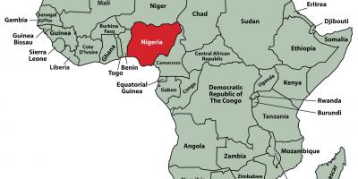
Understanding Nigeria: A Detailed Map of Drainage Systems
A map of Nigeria showing drainage systems is an essential tool that provides insight into the country’s complex network of rivers, lakes, and other water bodies. This map not only highlights the natural waterways that flow through Nigeria, but it also reveals the intricate drainage patterns that have developed over time. By understanding these drainage systems, we can appreciate their significance in terms of agriculture, transportation, and environmental management. The rivers and streams that crisscross the nation are not just geographical features; they are vital resources that support a vast range of activities in Nigeria.
The drainage systems depicted in such a map are crucial for understanding Nigeria's hydrology. The country has several major rivers, including the Niger and the Benue, which are fundamental to the livelihoods of millions of Nigerians. These rivers form a significant part of Nigeria's drainage system, collecting rainfall and directing water towards the Atlantic Ocean. The map illustrates how these rivers are interlinked, demonstrating their role in flood management and irrigation. A clear understanding of these waterways is essential for planning agricultural activities, especially in regions that depend heavily on rain-fed agriculture.
Historically, the drainage systems in Nigeria have shaped human settlement patterns and economic development. Rivers have served as important trade routes, facilitating commerce and the movement of goods. The Niger River, for example, has been a lifeline for communities along its banks for centuries, providing not only water but also fish and fertile land for farming. The map of Nigeria's drainage systems helps to visualize these historical connections, offering insights into how geography has influenced settlement and trade throughout the ages. Additionally, it aids in understanding how infrastructure development, such as roads and bridges, has been influenced by the presence of these waterways.
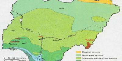
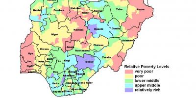
Geographically, the significance of Nigeria's drainage systems cannot be overstated. The country experiences diverse climatic conditions, which affect the distribution and flow of water. The map highlights regions that are prone to flooding, showcasing areas that require careful management to prevent environmental degradation. Furthermore, understanding the drainage patterns helps in identifying regions most vulnerable to climate change impacts, such as increased rainfall or droughts. This knowledge is crucial for policymakers and planners who aim to implement effective environmental management strategies.
Practically, a map of Nigeria showing drainage systems can be utilized in various fields, including agriculture, urban planning, and environmental conservation. Farmers can use this map to identify optimal locations for irrigation, while urban planners can design drainage systems that mitigate flooding risks in cities. Environmentalists can also benefit from this map by identifying critical ecosystems that depend on these water systems. Overall, the practical applications of this map are vast and vital for sustainable development in Nigeria.
In conclusion, a map of Nigeria showing drainage systems is a valuable resource that offers insights into the country’s geography, history, and practical applications. By understanding these drainage patterns, we can appreciate their significance in supporting livelihoods, managing natural resources, and planning for sustainable development. Exploring Nigeria's geography through this map opens up new avenues for research and understanding, enriching our knowledge of this diverse nation.
The map of Nigeria showing drainage systems is a critical tool for understanding the country's geography and environmental management. Delve deeper into Nigeria's rich landscape and discover the interconnectedness of its waterways.
-
Nigeria is home to the Niger River, the longest river in West Africa, stretching over 4,180 kilometers.
-
The Benue River is a significant tributary of the Niger River and is approximately 1,400 kilometers long.
-
The country has over 3,000 rivers, contributing to a diverse drainage system that supports agriculture and fishing.
-
Nigeria's largest lake, Lake Chad, is located in the northeastern part of the country and is subject to significant seasonal changes in size due to climate variations.
-
The Niger Delta, one of the world's largest deltas, is an area of rich biodiversity and is crucial for Nigeria's oil industry.
-
Flooding is a common occurrence in Nigeria, particularly in the rainy season, affecting millions of people each year.
-
The drainage patterns in Nigeria have been heavily influenced by both human activities and natural processes over centuries.
-
The country also experiences various types of wetlands, including marshes and swamps, which play a vital role in the drainage system.
-
Urbanization in Nigeria has increased the risk of flooding due to the alteration of natural drainage patterns and inadequate infrastructure.
-
Conservation efforts are ongoing in Nigeria to protect critical water bodies and improve drainage management to mitigate flood risks.