Explore Nigeria's Diverse Vegetation Through Detailed Maps
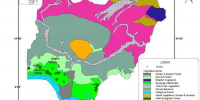
Nigeria, a country rich in diversity, boasts a variety of vegetation that reflects its geographic and climatic variations. A map of Nigeria showing the vegetation types is not merely a visual representation; it provides insights into the ecological zones that define this West African nation. From the lush rainforests in the south to the arid savannas in the north, this map acts as a critical tool for understanding Nigeria's natural resources and environmental challenges.
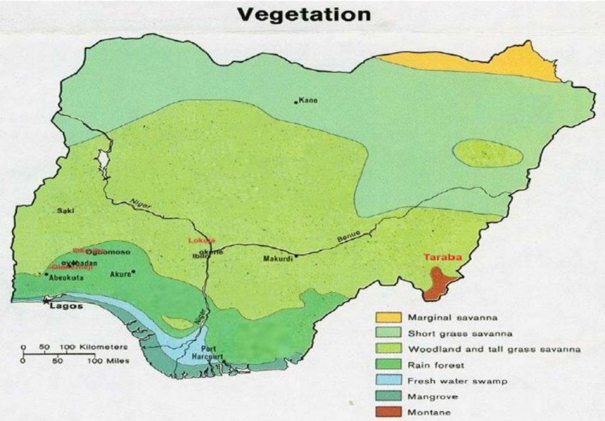
The vegetation map of Nigeria illustrates several distinct ecological zones, including mangroves, tropical rainforests, savanna grasslands, and montane forests. Each of these regions is home to unique flora and fauna, which play vital roles in biodiversity. For instance, the southern region, characterized by dense rainforests, supports a wide range of wildlife, including endangered species such as the Cross River gorilla. Understanding these vegetation types is essential for conservation efforts, as they highlight areas that require protection and sustainable management.
Historically, the vegetation of Nigeria has been influenced by both natural and anthropogenic factors. Over the decades, deforestation and agricultural expansion have significantly altered the landscape. The map serves as a historical document that can be used to study changes in land use and the impacts of climate change on vegetation patterns. As urbanization continues to rise, the need for sustainable land management practices becomes increasingly important; thus, the vegetation map becomes a vital reference point for policymakers and researchers.
Geographically, Nigeria's vegetation zones are closely linked to climatic conditions, with rainfall and temperature variations shaping the distribution of plant species. The northern regions experience a drier climate, leading to the prevalence of savanna ecosystems, whereas the southern regions benefit from higher rainfall, resulting in rich rainforests. This geographic significance highlights the interconnectedness of climate, vegetation, and human activities, offering valuable information for those studying environmental science and geography.
Practical uses of Nigeria's vegetation map extend beyond academics; they are instrumental for farmers, conservationists, and urban planners. For instance, understanding the vegetation types helps farmers select appropriate crops that thrive in specific regions, thereby enhancing agricultural productivity. Conservationists can utilize the map to identify critical habitats that need safeguarding. Additionally, urban planners can ensure that development projects take into account the surrounding natural ecosystems, promoting sustainable growth.
In summary, the map of Nigeria showing the vegetation is more than just a representation of plant life; it encapsulates the rich biodiversity, historical context, and geographic significance of Nigeria's ecosystems. By studying this map, one gains insights into the environmental challenges facing the nation and the importance of preserving its natural heritage. Whether for educational purposes or practical applications, this map serves as an essential resource for anyone interested in Nigeria's geography and ecology.
In conclusion, the vegetation map of Nigeria is a powerful tool for understanding the country's diverse ecosystems. Explore this map further to appreciate the intricate relationships between geography, climate, and biodiversity in Nigeria.
-
Nigeria has over 17 different vegetation types, reflecting its diverse climate and topography.
-
The Niger Delta region, known for its mangroves, is one of the most biodiverse areas in the world.
-
Nigeria's tropical rainforests are home to over 8,000 species of plants, many of which are endemic.
-
The northern savanna region is characterized by grasslands and scattered trees, providing habitat for wildlife such as elephants and lions.
-
Deforestation rates in Nigeria are among the highest in the world, with over 400,000 hectares lost each year due to agriculture and logging.
-
The Nigerian vegetation map was first created in the early 20th century and has been updated to reflect environmental changes.
-
Agricultural practices in Nigeria vary by region, with crops like yams, cassava, and maize being cultivated in fertile areas.
-
The Jos Plateau is known for its montane forests, which provide unique habitats for several endemic species.
-
Climate change has led to shifts in vegetation types, with some areas experiencing desertification while others see increased rainfall.
-
Nigeria is home to the largest expanse of tropical rainforest in West Africa, making it critical for global biodiversity preservation.