Explore the Relief Map of Nigeria: A Guide to Geography
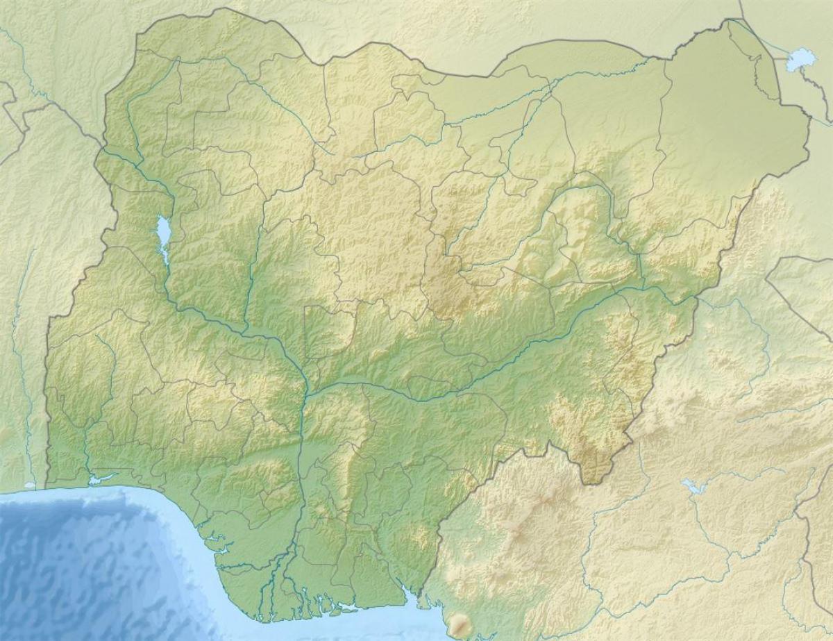
Nigeria's relief map is a powerful tool that illustrates the country's varied topography. This map highlights features such as mountains, plateaus, valleys, and plains, showcasing the diverse landscapes that make Nigeria unique. Understanding this relief is essential, as it affects climate, vegetation, and human activities across the nation. For instance, the Jos Plateau, located in the central region, is known for its high altitude and cooler temperatures, contrasting with the hot, low-lying areas of the Niger Delta. By examining the relief map, we gain insight into how geography influences settlement patterns, agriculture, and even economic activities in Nigeria.
Historically, the relief map of Nigeria has played a crucial role in defining socio-economic development. The strategic location of the Niger River, which flows through Nigeria and forms part of the country's eastern border, has been vital for trade and transportation. The river's basin, characterized by fertile plains, has supported agriculture for centuries, making it a cornerstone of the Nigerian economy. Conversely, the mountainous regions in the north, such as the Mambilla Plateau, present challenges for infrastructure development and accessibility. These geographical considerations are essential for understanding Nigeria's historical progression and development.
Geographically, Nigeria is richly endowed with diverse landforms that contribute to its ecological richness. The country is home to several natural resources, including minerals and agricultural land, all of which are influenced by the country's relief. The northern regions, characterized by savannahs and semi-arid zones, contrast sharply with the lush rainforests of the southern regions. This variety not only contributes to Nigeria's biodiversity but also affects local climates, wildlife habitats, and human settlement. A detailed relief map serves as a crucial reference for scientists, environmentalists, and urban planners looking to understand and manage these resources sustainably.
Additionally, the practical applications of Nigeria's relief map extend into education and tourism. Schools utilize these maps to teach students about Nigeria's geography, fostering a sense of national identity and awareness of local environments. Tourists and adventurers also rely on these maps to explore Nigeria's natural wonders, from the spectacular Olumo Rock in Ogun State to the stunning landscapes of the Niger River Delta. By providing a clear visual representation of the terrain, the relief map enhances the experience of exploring Nigeria's rich cultural and natural heritage.
In conclusion, the relief map of Nigeria is more than just a geographic representation; it is a vital resource that informs various sectors, including education, tourism, and environmental management. Understanding Nigeria's topography provides essential insights into the country's past and present, empowering individuals and organizations to make informed decisions. Whether you are a student, a researcher, or a traveler, engaging with Nigeria's relief map opens up a world of knowledge about this vibrant nation and its diverse landscapes.
Exploring Nigeria's relief map not only enhances our understanding of its geography but also highlights the intricate relationship between landforms and human activity. Dive deeper into Nigeria's geography to uncover more fascinating insights.
-
Nigeria's highest point is the Chappal Waddi, which stands at 2,419 meters above sea level, located in the Taraba State.
-
The Niger River, the longest river in Nigeria, flows for about 1,600 kilometers and is crucial for trade and agriculture in the region.
-
Nigeria has three main geographical zones: the coastal plains in the south, the central highlands, and the northern plains, each with distinct climates.
-
The Jos Plateau, located in central Nigeria, has a unique climate that supports crops like potatoes and maize, making it an agricultural hub.
-
Lake Chad, located in the northeastern part of Nigeria, is one of the largest lakes in Africa, although it has been shrinking due to climate change and water diversion.
-
About 70% of Nigeria's population is engaged in agriculture, primarily in the fertile regions along the Niger River and its tributaries.
-
The country is endowed with natural resources, including oil reserves primarily located in the Niger Delta, significantly impacting its economy.
-
Nigeria's diverse ecosystems range from tropical rainforests in the south to savannahs in the north, home to various endemic species.
-
The Niger Delta is one of the world's largest deltas and is known for its rich biodiversity, including mangroves and numerous bird species.
-
Nigeria has over 250 ethnic groups, and its geography influences cultural practices, agricultural methods, and settlement patterns across these groups.