Explore the Detailed Map of Nigeria: Geography and Insights

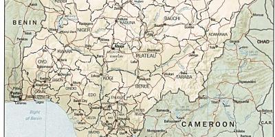
The map of Nigeria is not just a tool for navigation; it is a gateway to understanding the rich tapestry of this West African nation. Covering about 923,769 square kilometers, Nigeria is the most populous country in Africa, with over 200 million residents. This detailed map highlights the country's diverse landscapes, from the coastal regions along the Atlantic Ocean to the arid terrains in the north. It provides insight into the various states, cities, and geographical features that define Nigeria's identity.
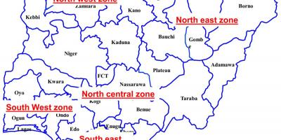
One of the most significant aspects of the detailed map of Nigeria is its portrayal of the country's six geopolitical zones: North Central, North East, North West, South East, South South, and South West. Each zone has its unique cultural heritage, economic activities, and historical background. For instance, the North is predominantly known for its agriculture and livestock farming, while the South is famous for its oil production and vibrant trade activities. Understanding these zones is crucial for anyone looking to grasp Nigeria's socio-economic dynamics.
Historically, the map of Nigeria provides context to the colonial past that shaped the modern nation. The British colonial administration merged various ethnic groups and regions into what is now Nigeria. This historical amalgamation has influenced the current political landscape and inter-ethnic relations within the country. A detailed map illustrates the locations of important historical sites, including ancient kingdoms, colonial buildings, and significant battlefields, which are essential for anyone studying Nigeria's history.
Geographically, Nigeria is rich in natural resources, including oil, gas, coal, and minerals. The detailed map highlights these resources and their locations, providing valuable information for investors and researchers. The Niger River, which flows through the country, is also marked on the map; it serves as a vital waterway for trade and transportation, linking various regions of Nigeria. Furthermore, the various national parks and wildlife reserves depicted on the map showcase Nigeria's commitment to preserving its rich biodiversity.
In practical terms, the map of Nigeria is a useful resource for travelers, educators, and businesses. Travelers can use the map to plan their journeys, discover tourist attractions, and understand the geographical challenges they may face. Educational institutions can incorporate the map into their curriculum to teach students about geography, history, and cultural studies. Businesses can also leverage the map to identify potential markets and logistics routes across the vast country.
In summary, the detailed map of Nigeria is an invaluable resource that offers insights into the country's geography, history, and socio-economic landscape. By understanding the regions, cultural diversity, and resources highlighted on this map, individuals can gain a deeper appreciation of Nigeria's complexity and vibrancy.
The map of Nigeria is not just a representation of borders; it is a reflection of the nation's identity and diversity. Exploring this map opens up new avenues to appreciate Nigeria's geography and its cultural wealth.
-
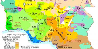
Nigeria is home to over 250 ethnic groups, with the three largest being the Hausa, Yoruba, and Igbo.
-
The Niger River is the third-longest river in Africa, stretching approximately 4,180 kilometers.
-
Nigeria's coastline along the Atlantic Ocean is about 853 kilometers long, featuring beautiful beaches and rich marine biodiversity.
-
The country has over 400 languages spoken, making it one of the most linguistically diverse nations in the world.
-
Nigeria is the largest producer of oil in Africa and is a member of the Organization of the Petroleum Exporting Countries (OPEC).
-
The Aso Rock, a prominent 400-meter tall rock formation, is located in Abuja, the capital city of Nigeria.
-
Nigeria's population is projected to surpass 400 million by 2050, making it the third most populous country globally, after India and China.
-
The country has over 20 national parks, including the famous Yankari National Park, known for its hot springs and diverse wildlife.
-
Nigeria's Lake Chad has shrunk by over 90% since the 1960s, posing significant challenges to the communities that depend on it.
-
The city of Lagos is one of the fastest-growing cities in the world, with a population exceeding 14 million people.