Explore the Map of Nigeria Showing Relief Features and Landscapes
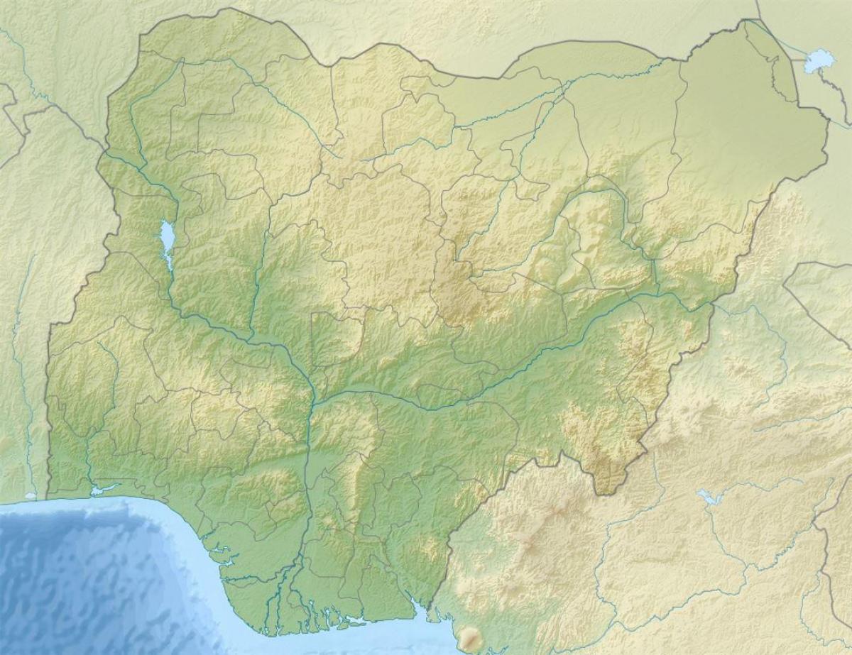
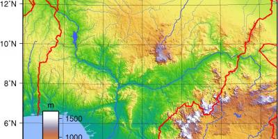
A map of Nigeria showing relief is an essential tool for understanding the country's complex geography. This map visually represents the variations in elevation across Nigeria, providing insights into its diverse landscapes, from the coastal plains of the south to the mountainous regions in the northeast. The relief map highlights significant features such as the Jos Plateau, the Niger and Benue Rivers, and the vast plains of the northern regions, making it an invaluable resource for students, researchers, and anyone interested in Nigerian geography.
Understanding the relief features of Nigeria is crucial for several reasons. First, it informs us about the various ecosystems present within the country. For instance, the mountainous areas of the northeast, such as the Mambilla Plateau, support different flora and fauna compared to the wetlands of the Niger Delta. Additionally, knowing the elevation changes can aid in agriculture, as certain crops thrive better in specific altitudes and climates. The relief map thus serves as a guide for farmers and agricultural planners in selecting suitable areas for crop production.
Historically, the geographic features represented on the relief map have played a significant role in shaping Nigeria's development. The Niger River, one of the longest rivers in Africa, has been a vital waterway for trade and transportation throughout history. The map illustrates how the river's course has influenced settlements and trade routes, enabling the growth of cities such as Onitsha and Port Harcourt along its banks. Furthermore, the topography has impacted historical events, including military campaigns and migrations, as certain areas were more accessible than others.
Geographically, Nigeria's relief map is significant because it provides context for various climatic zones across the country. The northern regions experience a semi-arid climate, while the southern parts are characterized by a tropical climate with abundant rainfall. These climatic variations, as depicted on the relief map, affect water resources, agricultural practices, and settlement patterns. Understanding these geographic factors is essential for effective planning and development in Nigeria, especially in addressing challenges such as climate change and resource management.
The practical uses of a relief map of Nigeria extend to education, tourism, and urban planning. For educators, it serves as a teaching tool to introduce students to geography, topography, and environmental science. Tourists can benefit from this map by gaining insights into the natural attractions of Nigeria, such as the Aso Rock, Olumo Rock, and the various national parks where unique landscapes can be explored. Urban planners can utilize this information to design infrastructure that is suited to the land's characteristics, ensuring sustainable development.
In conclusion, the map of Nigeria showing relief features is more than just a geographical representation; it is a comprehensive tool that provides insights into the country's landscapes, history, and environmental considerations. By exploring the relief map, one can appreciate Nigeria's diverse geography and the vital role it plays in shaping the nation's identity and future.
The map of Nigeria showing relief features is an essential resource for understanding the country's geography and landscapes. We encourage you to explore more about Nigeria's diverse environments and their significance.
-
Nigeria is the most populous country in Africa, with over 200 million residents, and its varied relief influences population distribution.
-
The Jos Plateau, located in central Nigeria, is known for its unique biodiversity and cooler climate, making it a popular retreat from the heat of the lowlands.
-
The Niger River is the third-longest river in Africa, spanning about 4,180 kilometers and serving as a critical waterway for trade and transport in Nigeria.
-
Nigeria's terrain includes coastal plains, savannahs, and mountainous regions, which contribute to its diverse ecosystems and agricultural practices.
-
The highest point in Nigeria is Chappal Waddi, reaching an elevation of 2,419 meters, located in the Mambilla Plateau.
-
The Niger Delta region is one of the world's largest river deltas, rich in biodiversity and a significant area for oil production.
-
Nigeria is home to several national parks, including Yankari National Park, which features hot springs and diverse wildlife, highlighting the importance of geography.
-
The country experiences a variety of climates due to its topography, ranging from tropical in the south to arid in the north, impacting agriculture and lifestyle.
-
Nigeria's relief map reveals numerous waterfalls, with the Kalakuta Falls and the Owu Falls being among the most notable attractions.
-
The geographical diversity of Nigeria influences cultural practices, with different ethnic groups adapting their lifestyles to the various landscapes they inhabit.