Explore the Physical Map of Nigeria: Geography and Insights
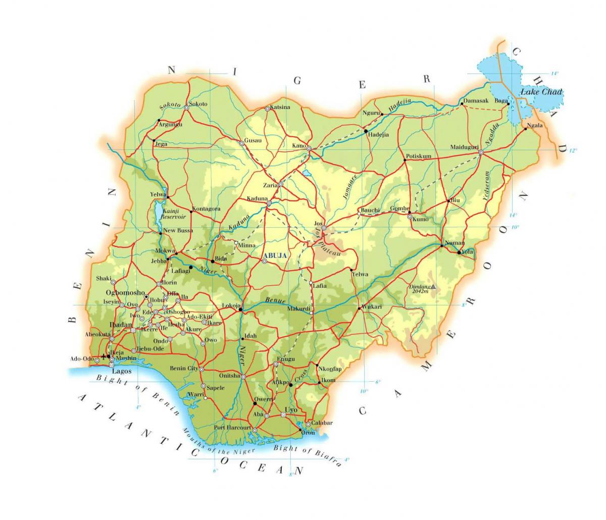
The physical map of Nigeria provides an intricate view of the country's diverse landscapes, including its mountains, rivers, forests, and other natural features. Nigeria, located in West Africa, is home to an array of geographical features that play a significant role in its ecological and cultural contexts. This map highlights the various terrains that make Nigeria unique, from the coastal areas along the Atlantic Ocean to the highlands in the northeastern region. Understanding the physical geography of Nigeria is essential for grasping the complexities of its climate, biodiversity, and human activities.
One of the most notable features depicted on the physical map is the Niger River, which is one of the longest rivers in Africa. The Niger River flows over 4,180 kilometers and is vital for transportation, agriculture, and fishing in Nigeria. The river's delta, known as the Niger Delta, is a densely populated area rich in biodiversity and oil reserves. Additionally, the map showcases the Jos Plateau, known for its rugged terrain and cooler climate, which contrasts sharply with the hotter, drier regions of the north. This geographical diversity impacts agricultural practices, settlement patterns, and economic activities across the country.
The historical context of Nigeria's physical geography is equally important. The country has been shaped by both natural processes and human activities over centuries. For instance, the interplay between the Sahara Desert to the north and the humid tropics to the south creates distinct climatic zones. This variation has influenced historical migration patterns, trade routes, and the development of different cultures and societies. The physical map serves as a visual representation of these historical dynamics, illustrating how geography has played a pivotal role in the evolution of Nigeria as a nation.
Geographically, Nigeria's significance extends beyond its borders. As the most populous country in Africa, Nigeria's physical map is crucial for understanding regional issues such as climate change, deforestation, and urbanization. The location of Nigeria along the Gulf of Guinea allows for significant maritime trade, while its diverse environments support a wide range of flora and fauna. This biodiversity is essential for conservation efforts and sustainable development, making the physical map a valuable tool for researchers, policymakers, and environmentalists alike.
Practical uses of the physical map of Nigeria are numerous. It is an essential resource for students, educators, and anyone interested in geography. The map can assist in planning infrastructure projects, managing natural resources, and responding to environmental challenges. Furthermore, the physical map is useful for tourists seeking to explore Nigeria's natural attractions, such as national parks, mountains, and rivers. By visualizing the country's geography, visitors can better appreciate the natural beauty and cultural richness that Nigeria has to offer.
In conclusion, the physical map of Nigeria is more than just a representation of its geographical features; it is a gateway to understanding the country's diverse landscapes, historical context, and ecological significance. By exploring this map, individuals can gain valuable insights into Nigeria's environment and its impact on society. Whether for educational purposes or personal exploration, the physical map serves as a vital resource for appreciating the complexity of Nigeria's geography.
The physical map of Nigeria offers a wealth of knowledge about the country's diverse landscapes and geographical features. We encourage you to explore further and discover the beauty and complexity of Nigerian geography.
-
Nigeria is the largest country in Africa by population, with over 200 million residents.
-
The Niger River is the third-longest river in Africa, after the Nile and the Congo.
-
Nigeria has over 250 ethnic groups, with the Hausa, Yoruba, and Igbo being the largest.
-
The Jos Plateau, located in central Nigeria, is known for its cooler temperatures and rich mineral deposits.
-
Nigeria's coastline stretches over 850 kilometers along the Atlantic Ocean, offering significant maritime trade routes.
-
Lake Chad, once one of the largest lakes in Africa, has drastically shrunk over the years due to climate change and overuse of water resources.
-
The country's geography includes the only rainforest in West Africa, located in the southeastern region.
-
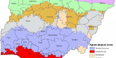
Nigeria has diverse ecosystems, including mangroves, savannas, and grasslands, which support a variety of wildlife.
-
Mount Chappal Waddi is the highest peak in Nigeria, standing at 2,419 meters above sea level.
-
The country's varied climate ranges from arid in the north to tropical in the south, influencing agriculture and biodiversity.