Comprehensive Map of Nigeria Showing All 36 States and Their Capitals
Nigeria, Africa's most populous country, consists of 36 states and one Federal Capital Territory. A map of Nigeria showing these states and their capitals serves as an essential resource for understanding the nation's political and geographical landscape. Each state has its unique cultural heritage, economic activities, and historical significance, making the map not just a navigational tool but also a window into the diverse life of Nigerians.
The map of Nigeria is more than just a representation of geography; it reflects the country's rich history and complex socio-political structure. Since gaining independence from British colonial rule in 1960, Nigeria has undergone significant changes in its administrative divisions. The creation of states was aimed at ensuring balanced regional representation and resource allocation. Understanding the locations of these states and their capitals is crucial for anyone looking to grasp Nigeria's political dynamics.
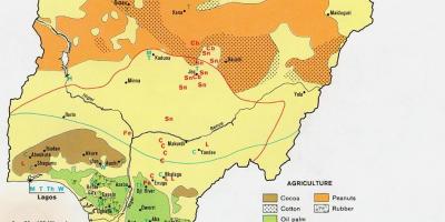
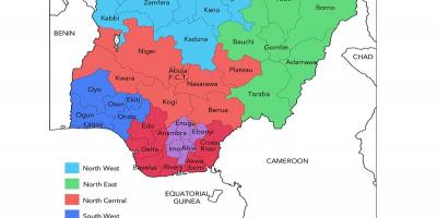
Geographically, Nigeria is divided into six geopolitical zones, each consisting of several states. These zones play a vital role in the political and social structure of the country. For instance, the Northern region, which includes states like Kano and Borno, is known for its agricultural and mineral resources. The Southern region, home to Lagos and Rivers states, is more urbanized and industrialized. By studying the map, one can appreciate how geography influences economic activities, cultural practices, and even political affiliations across the states.
The practical uses of a map of Nigeria showing states and capitals extend beyond academics and tourism. For businesses looking to invest in Nigeria, understanding the geographical distribution of states can inform market entry strategies and resource allocation. Furthermore, policymakers can utilize this map to identify regions that require development assistance or infrastructural investment. Travelers can also benefit from this map by gaining insights into the major cities and regions worth exploring.
In addition, the map can serve as a tool for educational purposes. Schools and universities can use it to teach students about Nigeria's geography, history, and cultural diversity. Incorporating maps into educational curricula can enhance students' understanding and retention of geographical knowledge. Moreover, it encourages students to engage with their country's history actively and understand regional differences within Nigeria.
In conclusion, a map of Nigeria showing all 36 states and their capitals is a valuable resource for various stakeholders, including students, researchers, businesses, and tourists. It encapsulates the essence of Nigeria, providing insights into its rich cultural tapestry and geographical layout. By exploring this map, one can better appreciate the complexities and beauty of Nigeria as a nation.
Exploring the map of Nigeria offers a deep understanding of its states and capitals, enhancing our appreciation for this diverse nation. Dive into the geography of Nigeria and discover more about its vibrant regions.
-
Nigeria is divided into 36 states and one Federal Capital Territory, Abuja, which serves as the capital city.
-
Lagos, the former capital, is the most populous city in Nigeria and is known as the commercial hub of West Africa.
-
Kano State is one of the oldest cities in Nigeria, known for its rich history and vibrant culture dating back over a thousand years.
-
The Niger River, one of the longest rivers in Africa, flows through several Nigerian states, providing vital resources for agriculture and transportation.
-
Benin City, the capital of Edo State, was once the center of the powerful Benin Empire, known for its remarkable art and culture.
-
The state of Rivers is home to Port Harcourt, a significant oil and gas hub, contributing to Nigeria's economy.
-
Enugu State is known as the 'Coal City State' due to its historical coal mining activities, which played a critical role in Nigeria's industrial development.
-
Abia State is recognized for its textile industry, particularly in the city of Aba, which is famous for its local fashion and manufacturing.
-
Kaduna State is located in the northern region and is known for its diverse ethnic groups and rich cultural heritage, including the famous Argungu Festival.
-
The geography of Nigeria varies from coastal plains in the south to savannah and mountainous regions in the north, showcasing the nation's diverse ecosystems.