Explore the Map of Nigeria Showing Geopolitical Zones
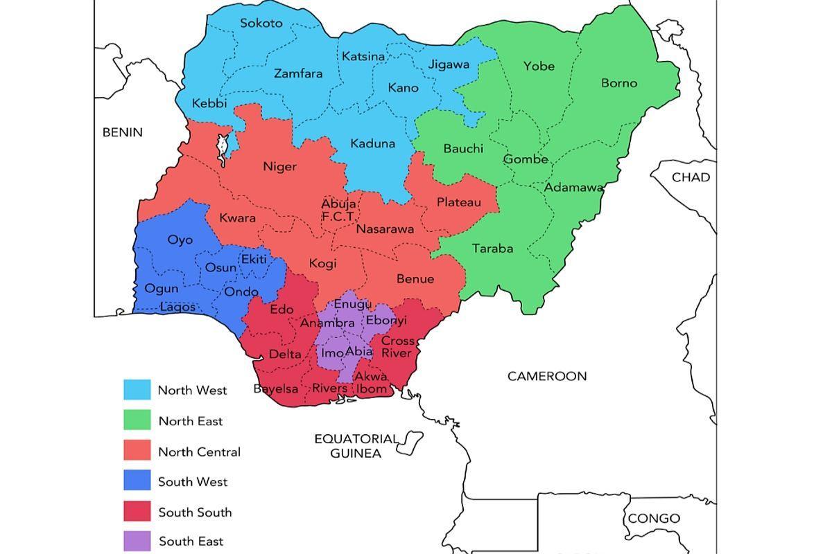
The map of Nigeria showing geopolitical zones is an essential tool for understanding the country's diverse cultural, economic, and political landscape. Nigeria is divided into six geopolitical zones: North Central, North East, North West, South East, South South, and South West. Each zone has its unique characteristics, cultures, and resources. This map not only visually represents these divisions but also illustrates the intricate socio-political dynamics within Nigeria. The geopolitical zones have been created primarily for administrative and political purposes, enhancing regional representation and governance. By analyzing this map, one can grasp how these zones influence development policies, resource allocation, and political representation across the nation.
Historically, the division of Nigeria into geopolitical zones emerged in the early 1990s. This strategic move aimed to address the ethnic and cultural diversity of the nation. Nigeria's population is made up of over 250 ethnic groups, with major ones including the Hausa, Yoruba, and Igbo. The geopolitical zones help to manage the complexities of this diversity by promoting inclusiveness and ensuring that various groups have a voice in government. For example, the North Central zone, often regarded as the Middle Belt, is known for its agricultural wealth, while the South West is recognized for its economic activities and urbanization.
Geographically, understanding Nigeria's geopolitical zones is crucial for various sectors, including education, healthcare, and infrastructure development. Different zones face unique challenges; for instance, the North East has been significantly affected by conflicts and security issues. In contrast, the South East is known for its rapid economic growth and industrial development. The map highlights these regional disparities, showing where resources are concentrated and where they are needed most. This spatial awareness is invaluable for NGOs, government agencies, and international organizations working on development projects across Nigeria.
Additionally, this map serves practical purposes in urban planning and transportation. By identifying specific zones, planners can develop tailored strategies that address local needs. For instance, the North West zone, which is more rural, may require different transport solutions than the urbanized South West. Understanding these differences allows for more effective policy formulation and implementation. Furthermore, businesses looking to invest in Nigeria can use this map to identify potential markets, labor availability, and regional partnerships.
In conclusion, the map of Nigeria showing geopolitical zones is more than just a geographical representation; it is a vital tool that encapsulates the country's complexities. It highlights the significance of regional dynamics in shaping Nigeria's political and economic landscape. By exploring this map, one can gain insights into the historical context, geographic significance, and practical applications of Nigeria's geopolitical divisions. This understanding is crucial for anyone looking to engage with Nigeria, whether for business, governance, or education.
In summary, the map of Nigeria showing geopolitical zones is essential for understanding the country's rich diversity and complex dynamics. We encourage you to explore further and discover more about Nigeria's geography and its impact on society.
-
Nigeria is the most populous country in Africa, with over 200 million people and more than 250 ethnic groups.
-
The North West zone is home to the largest concentration of people in Nigeria, including major cities like Kano and Kaduna.
-
The South East zone is recognized for its vibrant Igbo culture, which plays a significant role in Nigeria's economy and trade.
-
The North Central zone, often referred to as the Middle Belt, is known for its agricultural output, including crops like maize and cassava.
-
The South South zone is rich in oil and gas resources, making it crucial for Nigeria's economy, accounting for a significant portion of national revenue.
-
The North East zone has been heavily impacted by the Boko Haram insurgency, affecting its development and security.
-
Lagos, located in the South West zone, is Nigeria's largest city and a major financial center in Africa.
-
Each geopolitical zone has its own unique dialects, customs, and traditions, contributing to Nigeria's rich cultural tapestry.
-
The introduction of geopolitical zones aimed to enhance inclusivity in governance and promote equitable resource distribution across regions.
-
Nigeria's geopolitical zones are often used in electoral processes to ensure fair representation of diverse groups in government.