Explore the Historical Map of Old Nigeria: A Geographic Journey
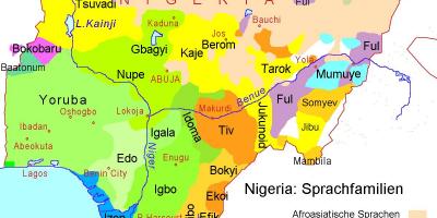
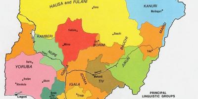
The historical map of old Nigeria is an essential resource for understanding the evolution of this West African nation. It showcases the various regions, tribes, and kingdoms that existed before Nigeria's unification in 1914. This map serves not only as a visual representation of the borders and territories but also highlights the rich cultural diversity and historical significance of Nigeria's regions. From the ancient empires of the Hausa-Fulani in the north to the vibrant Yoruba and Igbo cultures in the southwest and southeast, respectively, this map allows us to explore the intricate tapestry of Nigeria's past.
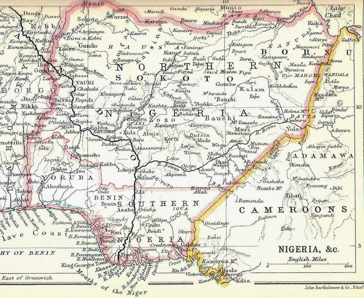
Understanding the historical context of this map is crucial to appreciating Nigeria's development over the years. The map illustrates how colonialism reshaped the landscape, merging different ethnic groups and cultures under one national identity. Originally, Nigeria was home to numerous independent kingdoms and chiefdoms, each with its own governance, language, and customs. Key historical territories depicted on the map include the Oyo Empire, the Benin Kingdom, and the Sokoto Caliphate, which played significant roles in trade, politics, and cultural exchange in West Africa.
Geographically, the map of old Nigeria is significant because it highlights the natural resources and trade routes that influenced economic activities. The Niger River, which traverses the country, is critical for transport and agriculture. The map points out major geographical features such as the Jos Plateau and the coastal regions, which contributed to the agricultural diversity and economic prosperity of various regions. Understanding these geographical elements helps in comprehending how the environment shaped human activities and settlement patterns throughout history.
The practical uses of the historical map of old Nigeria extend beyond mere academic interest. It is invaluable for researchers, historians, and students studying Nigerian history and culture. Schools and educational institutions can utilize this map to teach students about the country's rich heritage and the importance of its historical regions. Additionally, travelers and cultural enthusiasts can use the map as a guide to explore Nigeria's diverse landscapes and historical sites, connecting them to the rich narratives that have shaped the nation.
In summary, the map of old Nigeria is not just a collection of lines and colors; it embodies the stories, struggles, and triumphs of the Nigerian people throughout history. It serves as a powerful reminder of the need to understand and appreciate the complexities of Nigeria's past as we navigate its present and future. By exploring this map, we can gain insights into the cultural identity and geographic significance of Nigeria, fostering a deeper appreciation for its heritage.
The historical map of old Nigeria is a gateway to understanding the rich tapestry of this nation. We encourage you to delve deeper into Nigeria's geography and history to uncover even more fascinating insights.
-
The Kingdom of Benin, known for its advanced governance and artistry, was one of the most powerful states in Nigeria before colonial rule.
-
The Oyo Empire, a Yoruba state, was renowned for its military prowess and influence over trade routes in West Africa.
-
The Sokoto Caliphate, established in the early 19th century, became one of the largest empires in Africa, promoting Islamic education and trade.
-
Nigeria is home to over 250 ethnic groups, each with distinct languages and cultural practices, showcasing the country's diversity.
-
The Niger River, which flows through Nigeria, is one of the longest rivers in Africa, playing a vital role in transportation and agriculture.
-
The Jos Plateau is notable for its unique landscape and was a significant center for tin mining during the colonial era.
-
The ancient city of Kano was a major player in the trans-Saharan trade, known for its textiles, leather goods, and agricultural products.
-
The Yoruba people have a rich tradition of oral literature, with stories and proverbs passed down through generations, highlighting their cultural heritage.
-
The Atlantic coast of Nigeria is characterized by its mangroves and diverse marine life, contributing to local fisheries and tourism.
-
The British colonial administration in Nigeria began in the late 19th century, drastically altering the political boundaries and societal structures that existed prior.